گروه تخصصی آموزش کامپیوتر و اینترنت ؛ ترفند ،موبایل ،ویستا ، .
گروه تخصصی آموزش کامپیوترگروه تخصصی آموزش کامپیوتر و اینترنت ؛ ترفند ،موبایل ،ویستا ، .
گروه تخصصی آموزش کامپیوترآموزش کامل وتصویری نوشتن نستعلیق درفتوشاپ
آموزش کامل وتصویری نوشتن نستعلیق درفتوشاپسلام دوستان
این آموزش هم یک آموزش تکراری هست اما یک آموزش کاربردی میباشد که لازم بود به صورت تصویری ارایه شود
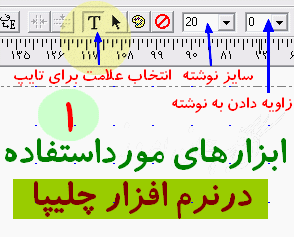
برای نوشتن نستعلیق نیاز به نرم افزار چلیپا هست که میتوانید از اینجا یا اینجا یا اینجا دانلود کنید
بعدازنصب برنامه چلیپا ونیز نرم افزارفتوشاپ را بازنماییدوطبق تصاویرارسالی زیر عمل نمایید تا شما هم بهصورت حرفه ای نوشتن نستعلیق درفتوشاپ رایاد بگیرید
این آموزش هم یک آموزش تکراری هست اما یک آموزش کاربردی میباشد که لازم بود به صورت تصویری ارایه شود
برای نوشتن نستعلیق نیاز به نرم افزار چلیپا هست که میتوانید از اینجا یا اینجا یا اینجا دانلود کنید
بعدازنصب برنامه چلیپا ونیز نرم افزارفتوشاپ را بازنماییدوطبق تصاویرارسالی زیر عمل نمایید تا شما هم بهصورت حرفه ای نوشتن نستعلیق درفتوشاپ رایاد بگیرید
چگونه دو کامپیوتر را با کابل usb یکدیگر متصل کنیم
چگونه دو کامپیوتر را با کابل usb یکدیگر متصل کنیمآیا می دانید که می توان 2 کامپیوتر را با یک کابل USBــ USB ساده به یکدیگر متصل کرد؟
اگر دو کامپیوتر در خانه یا محل کار خود دارید که برای استفاده اشتراکی از فایلهای موجود در هر کدام می خواهید آن دو را به یکدیگر وصل کنید. این روش یکی از سریعترین روشهای موجود است.
برای اتصال دو کامپیوتر استفاده از یک هاب یا روتر همیشه کار معقولی نیست. بلکه استفاده از یک کابل USBــ USB بسیار کاربردی و عملی تر است. با این روش حتی می توانید اتصال اینترنتی را بین دو کامپیوتر به اشتراک بگذارید.
در این آموزش کوتاه برای شما نحوه اتصال دو کامپیوتر با یک کابل خاص USBــ USB آموزش داده می شود.
1ــ یک کابل USBــ USB بخرید.
اولین مرحله برای اتصال دو کامپیوتر از طریق USB پیدا کردن کابل USBــ USB است در این مرحله باید بسیار دقت کنید. شما به نوعی کابل احتیاج دارید که اصطلاحاً به آن Bridge یا کابل شبکه USB می گویند. این بدان معناست که در این کابل قابلیت اتصال دو کامپیوتر وجود دارد.
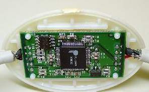
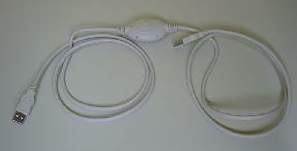 در این کابلها یک مدار الکتریکی واسط وجود دارد و دو سر کابل دارای سوکت نوع A است. شما می توانید کابلی بخرید که چیپ Bridge آن USB1.1 با سرعت 12 Mb بر ثانیه یا USB2.0 با سرعت 480 Mb بر ثانیه باشد البته توصیه ما USB2.0 است. چون سرعت آن به مراتب بیشتر است. به خاطر داشته باشید شبکه های اترنت دارای استاندارد 100 Mb بر ثانیه هستند.
 نصب نرم
اگر دو کامپیوتر در خانه یا محل کار خود دارید که برای استفاده اشتراکی از فایلهای موجود در هر کدام می خواهید آن دو را به یکدیگر وصل کنید. این روش یکی از سریعترین روشهای موجود است.
برای اتصال دو کامپیوتر استفاده از یک هاب یا روتر همیشه کار معقولی نیست. بلکه استفاده از یک کابل USBــ USB بسیار کاربردی و عملی تر است. با این روش حتی می توانید اتصال اینترنتی را بین دو کامپیوتر به اشتراک بگذارید.
در این آموزش کوتاه برای شما نحوه اتصال دو کامپیوتر با یک کابل خاص USBــ USB آموزش داده می شود.
1ــ یک کابل USBــ USB بخرید.
اولین مرحله برای اتصال دو کامپیوتر از طریق USB پیدا کردن کابل USBــ USB است در این مرحله باید بسیار دقت کنید. شما به نوعی کابل احتیاج دارید که اصطلاحاً به آن Bridge یا کابل شبکه USB می گویند. این بدان معناست که در این کابل قابلیت اتصال دو کامپیوتر وجود دارد.
نصب نرم داانلود گوگل ارث Google Earth Pro Gold Edition 2008
Google Earth Pro Gold Edition 2008
sameer in Softwares

For professional and commercial uses.
With Google Earth Pro, it’s easy to research locations and present your discoveries. In just a few clicks, you can import site plans, property lists or client sites and share the view with your client or colleague. You can even export high-quality images to documents or the web. Want to see it in action? Try it free for 7 days
Annotate and visualize
Represent your location-based data using 3D drawing tools, or transfer up to 2,500 locations by address or geospatial coordinates from a spreadsheet. The GIS Data Importing Module lets you incorporate GIS data in file formats such as .shp and .tab. Examples include parcel, demographic, and 3D building data.
Share and analyze
Share your Google Earth views and data representations with your clients as a KML, Google Earth‘s original file format. With your upgraded Pro subscription, you get additional measurement tools (square feet, mile, acreage, radius and so on), so simply select the points on the screen using your mouse and let Google Earth calculate the rest.
Create visually powerful presentations
Export high-resolution images up to 11″ x 17″ (4800 pixels, sample print - 890k), and use them in documents, presentations, web or printed materials. Your audience can come along for the ride as you create your own compressed movies (.wmv, sample movie - 13MB) of the zooms and virtual tours you take in Google Earth.

sameer in Softwares
For professional and commercial uses.
With Google Earth Pro, it’s easy to research locations and present your discoveries. In just a few clicks, you can import site plans, property lists or client sites and share the view with your client or colleague. You can even export high-quality images to documents or the web. Want to see it in action? Try it free for 7 days
Annotate and visualize
Represent your location-based data using 3D drawing tools, or transfer up to 2,500 locations by address or geospatial coordinates from a spreadsheet. The GIS Data Importing Module lets you incorporate GIS data in file formats such as .shp and .tab. Examples include parcel, demographic, and 3D building data.
Share and analyze
Share your Google Earth views and data representations with your clients as a KML, Google Earth‘s original file format. With your upgraded Pro subscription, you get additional measurement tools (square feet, mile, acreage, radius and so on), so simply select the points on the screen using your mouse and let Google Earth calculate the rest.
Create visually powerful presentations
Export high-resolution images up to 11″ x 17″ (4800 pixels, sample print - 890k), and use them in documents, presentations, web or printed materials. Your audience can come along for the ride as you create your own compressed movies (.wmv, sample movie - 13MB) of the zooms and virtual tours you take in Google Earth.
http://rapidshare.com/files/127264025/Google_Earth_Pro_Gold_Edition.rarOR
http://www.fast-load.net/index.php?pid=549dfe5fd253bc0f58b3de513b0ec0b6
داانلود گوگل ارث Google Earth Pro Gold Edition 2008
Google Earth Pro Gold Edition 2008
sameer in Softwares
For professional and commercial uses.
With Google Earth Pro, it’s easy to research locations and present your discoveries. In just a few clicks, you can import site plans, property lists or client sites and share the view with your client or colleague. You can even export high-quality images to documents or the web. Want to see it in action? Try it free for 7 days
Annotate and visualize
Represent your location-based data using 3D drawing tools, or transfer up to 2,500 locations by address or geospatial coordinates from a spreadsheet. The GIS Data Importing Module lets you incorporate GIS data in file formats such as .shp and .tab. Examples include parcel, demographic, and 3D building data.
Share and analyze
Share your Google Earth views and data representations with your clients as a KML, Google Earth‘s original file format. With your upgraded Pro subscription, you get additional measurement tools (square feet, mile, acreage, radius and so on), so simply select the points on the screen using your mouse and let Google Earth calculate the rest.
Create visually powerful presentations
Export high-resolution images up to 11″ x 17″ (4800 pixels, sample print - 890k), and use them in documents, presentations, web or printed materials. Your audience can come along for the ride as you create your own compressed movies (.wmv, sample movie - 13MB) of the zooms and virtual tours you take in Google Earth.
http://rapidshare.com/files/127264025/Google_Earth_Pro_Gold_Edition.rarOR
http://www.fast-load.net/index.php?pid=549dfe5fd253bc0f58b3de513b0ec0b6